Habitat mapping to support marine spatial planning
With an increased tensioning between the different users of the marine space (for example; fisheries, tourism and marine conservation), there is an urgent need for accurate habitat maps to help inform the marine spatial planning process. Work conducted through this project has therefore facilitated the production of habitat maps and the generation of critical marine environmental and ecosystem data for high-priority locations in Vanuatu, Belize and Dominica.
In Vanuatu, both submarine and aerial ground-truthing information (collected via a portable Remotely Operated Vehicle, ROV, and Unmanned Aerial Vehicle, UAV, respectively), were combined with bathymetric data previously obtained by our CME Programme partner, the UK Hydrographic Office, in order to provide the first detailed habitat map of the coastal areas near Mount Yasur Volcano on Tanna. The surveys conducted in Belize and Dominica provided the first applications of the Containerised Autonomous Marine Environmental Laboratory, resulting in, for example, the production of fine-scale habitat maps within Soufriere-Scott’s Head Marine Reserve and Cabrits National Park in Dominica, a high-resolution assessment of coral health and abundance within the Belize Barrier Reef, and quantification of the extent of seagrass meadows and sub-surface carbon burial within Turneffe Atoll. In all cases, the habitat maps and environmental information generated through this work provide a vital baseline environmental assessment against which any future changes can be measured, helping the development of effective management strategies that balance human pressures with the sensitivities of the marine ecosystems.
Countries supported
Belize; Dominica; Vanuatu
Outputs
- New habitat map produced for Port Resolution Bay and Sulphur Bay in Tanna, Vanuatu.
- Training of local partners in Remotely Operated Vehicle and Unmanned Aerial Vehicle mapping techniques and habitat mapping data interpretation.
- Bathymetric and ground-truthing surveys conducted using the CAMEL facility in Cabrits National Park and Soufriere-Scott’s Head Marine Reserve, Dominica, resulting in new fine-scale habitat maps for both areas.
- Bathymetric surveying and characterisation of sedimentary deposits under the seagrass beds of Turneffe Atoll, Belize, supporting an on-going Blue Carbon Assessment.
- Multi-parameter surveys of the Belize Barrier Reef and the Belize River turbidity plume, improving our understanding of the impacts of terrestrial run-off on coastal environments.
Publications
- Evaluating the sensor-equipped autonomous surface vehicle C-Worker 4 as a tool for identifying coastal ocean acidification and changes in carbonate chemistry. S. Cryer, F. Carvalho, T. Wood, J.A. Strong, P. Brown, S. Loucaides, A. Young, R. Sanders and C. Evans (2020). Journal of Marine Science and Engineering, 8, 939 doi:10.3390/jmse8110939
The Team


Latest News
Characterising the environmental sensitivity of Belizean coastal waters Oct 2019
 A month long fieldwork campaign has begun in Belizean coastal waters which will enhance understanding of the sensitivities of these fragile environments to the impacts of both human activities and climate change.
Dr Christopher Pearce, programme lead for the NOC, said “Belizean coastal environments are some of the most fragile in the world, and are facing a combination of challenges from both human and climate change factors.
In collaboration with our Belizean colleagues we will be...
A month long fieldwork campaign has begun in Belizean coastal waters which will enhance understanding of the sensitivities of these fragile environments to the impacts of both human activities and climate change.
Dr Christopher Pearce, programme lead for the NOC, said “Belizean coastal environments are some of the most fragile in the world, and are facing a combination of challenges from both human and climate change factors.
In collaboration with our Belizean colleagues we will be... |
High biodiversity discovered in abyssal areas of Kiribati Sep 2019
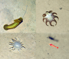 A study led by National Oceanography Centre (NOC) scientists, recently published in Frontiers in Marine Science, presents the first ever images of animals living below 4000 metres within the Exclusive Economic Zone (EEZ) of the Republic of Kiribati, a remote island group in the Pacific.
Industry-collected seabed photos revealed a high diversity, but low abundance, of complex animals. The majority of the observed seabed life was single-celled giant forams. This is comparable to similar...
A study led by National Oceanography Centre (NOC) scientists, recently published in Frontiers in Marine Science, presents the first ever images of animals living below 4000 metres within the Exclusive Economic Zone (EEZ) of the Republic of Kiribati, a remote island group in the Pacific.
Industry-collected seabed photos revealed a high diversity, but low abundance, of complex animals. The majority of the observed seabed life was single-celled giant forams. This is comparable to similar... |